Seismic: The structural foundation for confident exploration and resource growth
.png)
Deeper targets. More complex geology. Tighter capital. The conditions facing exploration teams today have fundamentally increased the cost of being wrong.
When mineralisation sat closer to the surface, a missed hole was just part of the program, expensive but recoverable. When you are drilling beyond 500 metres into structurally complex ground, the cost of a poorly positioned hole, a misinterpreted fault, a target that looked compelling on a 2D section but fell apart in three dimensions, is a different order of problem. It is not just wasted metres. It is wasted time, wasted capital, and in some cases a program that loses the confidence of those funding it.
Modern mining is not not looking for more data, it's looking for deeper geological understanding before the bit hits the ground. The method that delivers that, consistently and at depth, is seismic.
■ Why seismic is the right response
Seismic converts geological uncertainty at depth into mappable structural constraints. It defines geometry, orientation, depth, and continuity in three dimensions. Seismic holds its resolution with depth greater than Aeromag and Gravity providing architecture clarity at all surveyed depths, not just the shallow ones, allowing for more precise insight into the architecture of the system.
Establishing the structural framework early changes the quality of every decision that follows. Targets can be ranked and positioned in three dimensions, uncertainty can be quantified, and drilling capital can be committed against a model the team can test, interrogate and trace back to the data supporting it.
Drilling sequences are designed so each hole tests a specific structural hypothesis. Each drill hole is more deliberately placed, more likely to intersect the intended target, and more interpretable when it returns results. The model and the drilling inform each other. Seismic designed, processed and interpreted specifically for hard rock mineral systems means you enter that conversation with far better prior knowledge.
What has changed is not the argument for seismic. It is the quality, speed, and integration capability of what modern programs can now access.
■ Built for mineral systems, not borrowed from oil and gas
Most seismic capability in the market was developed for oil and gas and adapted, with varying degrees of success for hard rock settings. The acoustic properties of hard rock are fundamentally different. The structural targets are different. The depth ranges, the survey geometries, the processing workflows, all of it requires a different approach.
Purpose-built seismic for mineral systems now spans high-resolution active seismic and real-time passive methods such as Ambient Noise Tomography (ANT). Dedicated hard-rock acquisition, processing and interpretation workflows have matured over two decades and hundreds of projects worldwide. ANT can now deliver 3D velocity models within 48 hours of deployment, with in-field data quality monitored in real time via satellite as acquisition progresses.
The result is seismic that is fit for purpose in the environments where modern exploration actually happens: remote terrain, environmentally constrained access, complex hard rock geology, and targets that conventional methods cannot resolve.
This was the case at Lundin Gold's Fruta del Norte deposit in Ecuador, one of the world's highest-grade operating gold mines, the main mineralisation sits under more than 200 metres of post-mineralisation cover. Traditional surface methods are ineffective, and the structural controls on mineralisation are complex, governed by steep faults.
Fleet deployed a high-resolution active seismic program across five lines totalling 26.4 kilometres, with 10-metre source and receiver spacing to achieve exceptional resolution.
As part of the survey results, one of the structural controls in the mineralisation, extended the East Fault to beyond 3.5 km depth, where previous methods had traced it to only 500 metres.
It also more precisely defined the basin contact and thickness variations, identified two new high-priority target zones correlating with zones of intense fracturing and brecciation. Within weeks of delivery, Lundin Gold's exploration team began drilling based on the interpretation.
That is what world-class seismic delivers in a hard rock setting: structural clarity that translates directly into clearer decisions.
Review the full Lundin Gold Case Study here 📎
■ Seismic as the foundation that amplifies everything else - making legacy data an active constraint.
Most programs sit on years of data accumulated across multiple methods. Integrated within a rigorous structural framework, that legacy data can be reinterpreted in context and put back to work, informing current interpretation, target ranking and drilling decisions.
When seismic establishes the structural framework first, the potential in other dataset becomes more transferable and interpretable. Anomalies that would otherwise sit in ambiguity can be evaluated in structural context.
This applies across multiple geophysical methods and geochemistry. Magnetotellurics identifies conductive zones associated with mineralised systems and fluid pathways, but conductors interpreted without structural context produce ambiguous results. Constrained against a seismic-derived structural model, MT conductivity becomes interpretable: anomalies that sit within the structural architecture are prioritised, those that fall outside it are deprioritised early, before capital is committed.

Gravity responds to the same logic. At Alkane Resources' Boda-Kaiser porphyry system in New South Wales, integrating ANT-derived velocity models with gravity data produced a coherent 3D geological framework that separated major lithological domains at camp scale and identified alteration signatures associated with gold-copper mineralisation at deposit scale, results neither dataset could have delivered independently.
.png)
At Barrick's Reko Diq project in Pakistan, one of the world's largest undeveloped copper-gold porphyry deposits, Fleet deployed ANT across five survey arrays covering both regional and deposit scales. The resulting 3D velocity models mapped the major structural trends controlling mineralisation, identified potential hypogene feeder zones, and provided an estimate of depth to the underlying batholith.

Legacy geological data and existing survey results were integrated against that framework throughout. At a project of this scale and complexity, structural clarity at that resolution is not just another part of the program. It is fundamental to making the next phase of exploration defensible.
This is how prior exploration investment compounds rather than depreciates. Each dataset, new or existing, contributes to a more complete picture of the system when it has a rigorous structural foundation to constrain against.
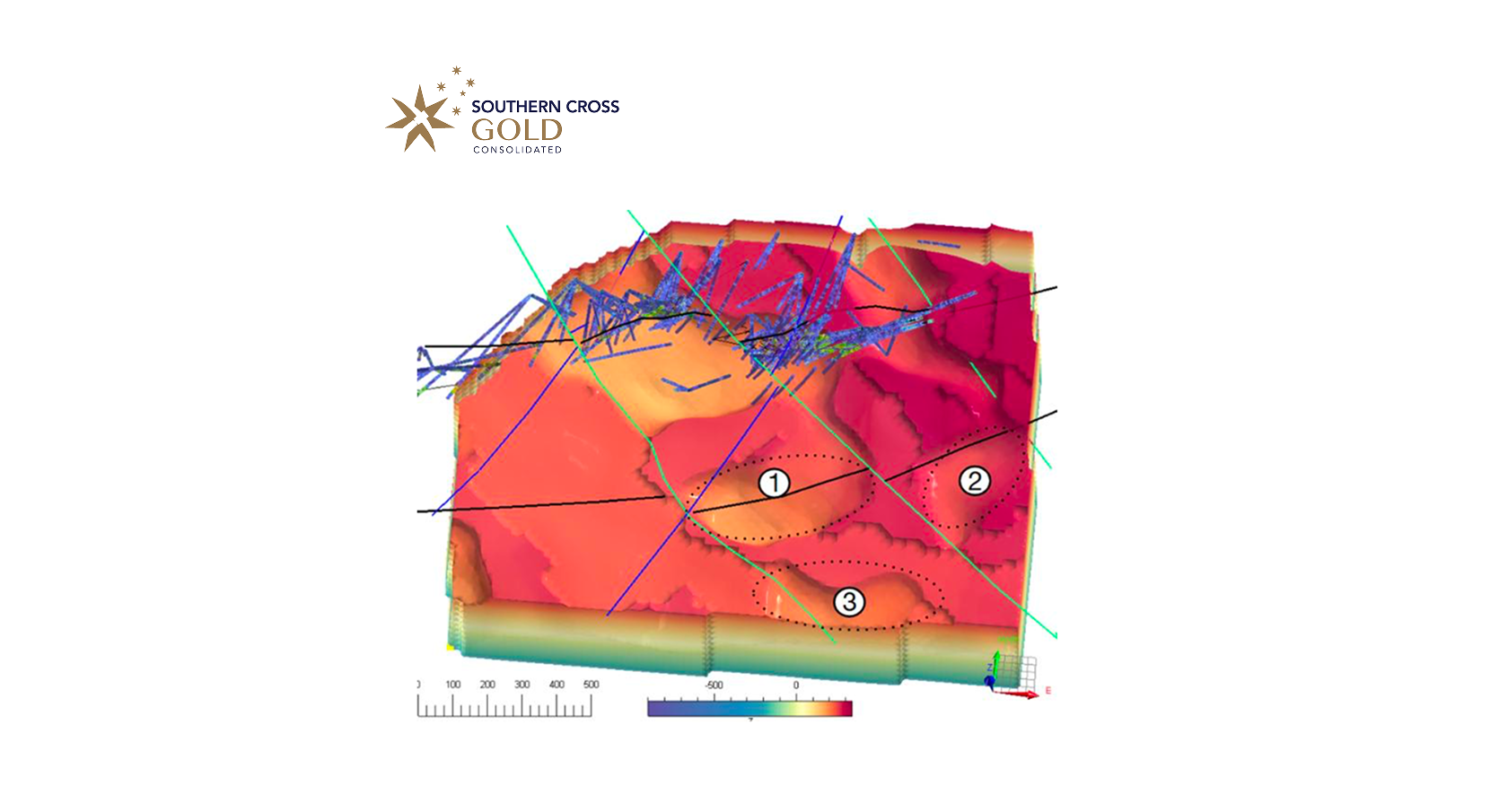
At Southern Cross Gold's Sunday Creek project in Victoria, ANT velocity models integrated with ground gravity data identified three distinct fault sets controlling mineralisation geometry, sharpening targeting confidence without any additional acquisition.
Structure alone doesn't say what a system is made of. Seismic defines where the architecture sits, the faults, the geometry, the depth extent, not the chemistry moving through it. That's a separate question, and it's the one Comet™ by Fleet answers.
Fleet's Comet platform extracts quantitative mineralogy directly from assay data already in hand. No new sampling. On its own, that mineralogy is a set of points: alteration intensity at each sample location, with no way to know how far the pattern extends or whether it follows the same architecture the drilling was designed around. Located inside the seismic-defined structural model, the same assay data becomes a 3D alteration footprint, tracked against specific faults and feeder zones rather than floating in isolation.
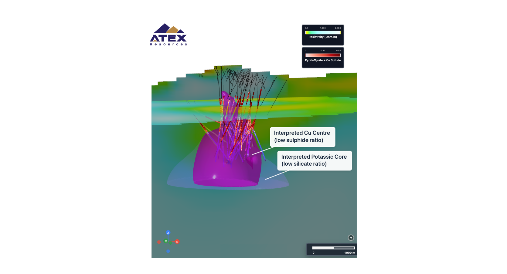
At Atex Resources Valeriano copper-gold porphyry in Chile, Comet produced a deposit-wide mineralogy model from existing drill hole assays: pyrite zonation, muscovite abundance vectors pointing toward further mineralised zones, and alteration domains with direct implications for metallurgical test work. Placed inside the structural model seismic had already built, those vectors point toward a specific volume of ground, not just a direction on a map.
Neither dataset does that alone. The value is in the integration.
Read the full Atex Resources' Valeriano Case Study 📎
AI and machine learning applied across these integrated datasets can then reveal patterns and rank targets at a scale manual interpretation workflows cannot match. The question worth asking of any ML-driven exploration approach is: what those patterns are anchored against?
■ Machine learning: from integrated evidence to ranked targets
Machine learning is not valuable simply because it finds patterns. Exploration data contains patterns everywhere. The question is whether those patterns reflect the geology, survive testing against drilling and carry enough confidence to support the next decision.
Seismic provides a natively 3D framework for combining velocity and reflectivity with MT, magnetics, gravity, mineralogy, geology and drilling. Machine learning can then evaluate relationships across the full subsurface volume, rather than flattening the problem into a map or isolated section.
■ Quantified uncertainty
A decision-grade model should not return a single predicted value. It should provide a most-likely value and an uncertainty range for each block, so targets can be ranked by both their predicted potential and the strength of the supporting evidence.
At ATEX Resources’ Valeriano project, the model was trained using 80% of the available drilling data, while 20% was withheld for blind testing. Across 613 held-out observations, predicted and actual copper grades achieved a Spearman correlation of 0.84. Spearman correlation measures how closely two rankings agree, where 1.0 represents perfect agreement. In practical terms, the model closely matched where drilling found higher and lower copper grades in data it had never seen.
That is the difference between reproducing data the model has already seen and testing whether its predictions hold against independent drilling evidence.
■ A living, ground-truthed 3D model
As new holes, assays and geophysical data arrive, the model can be updated and tested again. Predictions sharpen where the evidence agrees and uncertainty remains wider where the geology is poorly constrained.
The processing can be automated. The decision cannot, geoscientists and geophysicists still assess whether the inputs, patterns and target rankings make geological sense and address the uncertainty the program actually needs to resolve - the difference is now they have a model testable, traceable and explicit about uncertainty.
Know not only where the model points, but how much to trust it, calibrated against ground truth.
The result is not a black-box target. It is a ranked set of testable geological hypotheses, with quantified confidence and traceability back to the data that supports them.
■ From structural clarity to drilling decisions
Fleet's seismic technology has been validated across more than 500,000 metres of drilling. The output of every engagement is the same: defensible targets with clear traceability back to the integrated data that supports them. Not a model to just interpret. Not a report that generates further work.
When someone asks why target A ranks above target B there is a quantifiable, defensible answer.
That is what the shift to deeper, more complex exploration demands: not just better models of the subsurface, but a clearer path from the data to the decision. Seismic is where that path begins.
If your next program requires structural clarity at depth, talk to our exploration team about what that looks like for your ground.
You might also like
.png)