


The anomaly is real, but the geometry is a hypothesis. Reduce risk by data-enriching the most prospective areas and improving target confidence.
The challenge
You have anomalies.
You can't tell them
apart yet.
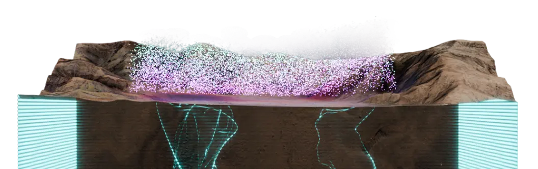
Resistivity contrasts mapped.
Data processed.
Still two competing structural interpretations.
At Target Definition, the data stack is often substantial: MT, IP, gravity, magnetics, surface mapping, and historical drilling. But each method produces its own inversion, its own interpretation, and its own geometry. When they don't agree, the structural picture remains non-unique.
Conductivity does not equal geology. The sulphide body and the clay alteration halo look identical in MT alone. A chargeability high from IP can indicate either pyrite or carbon. Drilling resolves the ambiguity, but drilling is not cheap, and the first hole sets the program's trajectory.
You've drilled enough to prove the system; what you don't have is the next target. Turn your own drilling into a model that finds where mineralisation repeats across untested, deeper and under-cover ground.
Your drilling proved the system...
so where's the next
target?
The solution
Seismic purpose built for Target Definition
Ambient Noise Tomography (ANT) deployed at high resolution with denser station spacing. Integrated against your existing geophysics. Structural ambiguity collapsed before the rig moves.
Resolved. Sulphides and clay alteration both produce conductive MT responses. They have different seismic velocity signatures. Integrating ANT velocity with MT resistivity resolves the ambiguity that single-method geophysics cannot. The same logic applies to porphyry centres versus alteration halos, mineralised intrusives versus barren conductors, and feeder systems versus discrete bodies.
When multiple 3D geometries explain the same MT dataset, adding velocity constraints from ANT narrows the solution space. Customers stop choosing between hypothetical geometries and start drilling against a single, jointly-constrained structural model.
Fleet integrates ANT velocity against everything you already own: MT, IP, gravity, magnetics, legacy drilling, assays, and geochemical datasets. Prior investment does not accumulate. It compounds into a better model.
ANT's performance continues at depths where conventional ground geophysics loses confidence and resolution. Fleet's ANT allows you to image the deep structural architecture critical to understanding the full extent of the mineral system.
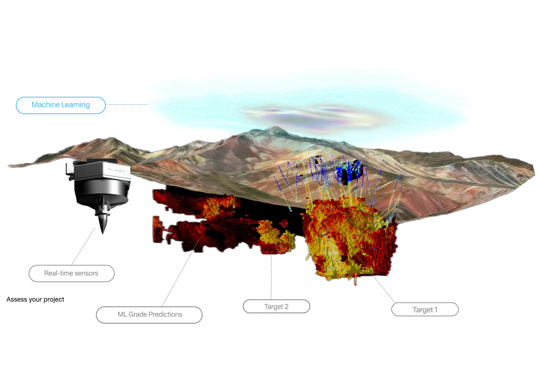
Geoscience expertise and ML combined to develop predictive models that extract greater value from your existing exploration data, improving geological understanding and driving prospectively decisions.
Machine Learning
Machine Learning targets trained on your ground truth.
Where drillhole data exists, supervised ML uses it as ground truth. Where it doesn't, unsupervised clustering partitions the 3D volume into geophysically consistent domains. Either way, every ranked target traces back to a physical property contrast, not a pattern in training data.
Each target carries a confidence score and a traceable reasoning path. Where uncertainty remains, it is named and quantified, not absorbed into a single interpretation. Geologists can interrogate the model, stress-test the geometry, and defend the ranking to their board.
The Fleet difference
Fleet works differently.
The only seismic and ML team dedicated entirely to mineral systems.
Built for hard rock. Not adapted from oil and gas.
Hard rock mineral systems are structurally discrete and complex at depth. Fleet's processing, channels, and methods are designed for that geology, not translated from sedimentary basin workflows.
Your existing data, properly constrained
Historical inversions are integrated, not discarded. Comet converts legacy assays into mineral domains. Prior investment becomes a structural foundation, not a liability.
3D structure resolved at depth
Understand mineral variability, hardness and sulfide behaviour early, reducing downstream processing risk.
Structural clarity within 48 hours of acquisition
Real-time QA/QC and data ingestion through ExoSphere means the structural framework arrives before downstream capital decisions are made, not after.
Passive acquisition. Works through any cover.
Passive seismic propagates through post-mineral sediment and weathering unimpeded. Deployable in days. No source requirements. No mobilisation constraints.
ML constrained by geology, not applied over it
Prospectivity modelling is anchored to the 3D velocity model. Supervised where drillhole data exists. Unsupervised cluster extraction where it doesn't. Either way, targets trace back to physical evidence.
Solutions
Start small.
Scale when value is proven.
Uncertainty AssessmentData Review and Report | 3D Structural MappingAmbient Noise Tomography | High-Resolution Imaging3D Active Seismic | |
|---|---|---|---|
Purpose | Quantify and understand subsurface uncertainty | Define 3D structure and collapse uncertainty | Precisely image known targets at high resolution |
What you get |
|
|
|
Resolution | Conceptual | District-scale 3D | Deposit-scale 3D |
Timing | ~1 week | 4-8 weeks | 8–16 weeks |
Outcome | Clear decision pathway. | District-scale clarity. Drill with confidence. | Drill-ready precision. |
Customer Impact
Ground truth for
in-the-field decisions

Challenge
High-grade copper-gold porphyry at depth. MT defined a broad conductive target but could not resolve fault architecture or intrusive geometry. No data-driven basis for prioritising the next drill campaign.
Solution
Meteor by Fleet workflow: ANT integrated with existing MT data, Comet mineralogy applied to differentiate ore from alteration, ML grade model trained on Cu assays and validated against three blind drill holes.
Impact
70% reduction in prospective search volume. New drill targets ranked by grade and confidence generated across a system still open NNW, SE, and at depth.
Challenge
Blind epithermal gold beneath 200m of post-mineralisation cover in remote jungle terrain. Surface methods and IP lacked resolution to define the fault controls. No structural basis for committing drill capital.
Solution
High-resolution 2D active seismic across five lines totalling 26.4 km, integrated with existing drillhole assays, geological models, and structural interpretations.
Impact
Two high-priority drill targets identified within weeks of delivery. Fault imaging extended to 3.5 km depth. Immediate drilling enabled. Promising early results.
Challenge
Gold project. Primary targets 600m below surface. Too many competing geological narratives. No model capable of resolving which targets warranted capital.
Solution
ANT survey integrated with legacy drill data, assays and gravity. ML ranking applied across the full search space.
Impact
Two targets confirmed drill-ready. Third target walked away. Saving estimated $3M in misallocated drilling spend.

Challenge
District-scale copper tenement. Drilling budget approved. Structural confidence too low to defend target sequencing.
Solution
ANT survey across 45 km² combined with existing magnetics and geology to build the first 3D structural framework. Integrated model delivered 48 hours after field acquisition.
Impact
Search space reduced from 11 zones to 3 priority corridors. Phase 1 drilling committed within 6 weeks.
Assess your project
Integrated 3D
seismic intelligence
Drill the right target first.
Ranked and traceable.
One constrained model.
- Integrate velocity against your geology, geophysics, geochemistry, and drill data.
- Collapse competing interpretations into a single, jointly-constrained 3D model.
- Rank targets by traceable confidence, with alteration and architecture indicators.
- Commit drill capital with collar coordinates, target depths, and ranked priority.

Award winning technology


Explore with Fleet
Seismic built for modern exploration
“When one innovative industry joins another, magic happens.”
-Flavia Tata Nardini,
Chief Executive Officer & Co-founder