Geophysics you can touch.
How we bridge
geophysics to geology.
.png)
Jan Hansen
Lead Computational Geophysicist
Dr. Tim Jones
Head of Exploration Science
We learned to love geology on field trips. Walking outcrops and unravelling the story written into the rocks, their minerals and the relationships between them is what got me hooked. Working across scales is the recurring theme: you read the outcrop as a whole, then zoom in, first to individual rocks, then to single minerals.
In the field, the tool of choice is simple: a hammer. Breaking a sample open exposes fresh rock, free of weathering, and gives us our first real look at what it's made of. We start with visual clues: colour, texture, crystal habit, to narrow down the minerals present. Combine that with other senses (licking a sample is a genuinely reliable way to tell halite from carbonate) and identification becomes fast and direct.
And the scales inform each other. The way minerals sit together at microstructural scale, their textures, their intergrowths, records the forces that shaped the rock, while the large-scale setting tells you what to expect back down at the grain. Read one well and you read the other better.
That's the advantage of fieldwork: both scales are within reach at once- you see the rock with your own eyes, and you turn it over in your hands.
That movement between scales is much harder in geophysics. We normally interpret a velocity or resistivity model using the language of geology: lithologies, contacts, structures and alteration zones. But those labels are interpretations, not what the instruments actually measure.
Geophysics measures physical properties. Those properties are influenced by the minerals in the rock, how they are arranged and connected, and the structures, pores and fluids around them. Two rocks given the same geological name can therefore produce different geophysical responses, while rocks with different names can sometimes appear physically similar.
Geophysicists understand this connection in principle. What has been missing is a practical way to connect quantitative mineralogy observed in drillholes with the physical properties represented in a 3D geophysical model.
■ What geophysics measures
At Fleet Space, we begin from much further away. Ambient Noise Tomography (ANT) gives us a 3D model of seismic velocity through the subsurface, while Magnetotellurics adds electrical resistivity as a second, independent view of the physical state of the rock.
Combining physical properties helps reduce ambiguity, but it does not automatically tell us what they mean geologically. A velocity high, velocity low or conductor can have several possible causes. The same host rock can also change its physical response when hydrothermal fluids replace its original minerals with a new alteration assemblage.
The missing step is a reliable way to connect those physical-property responses with the mineral assemblages observed in drilling.
■ Drilling is the ground truth, but only where the hole goes
A drillhole gives us extraordinary detail along a very narrow line. The challenge is understanding the volume between those lines.
Geophysics is what combines that ground truth across boreholes and shows what's happening in the rock between them, turning a handful of one-dimensional holes into a continuous three-dimensional picture. With Comet, Fleet's mineral-inversion engine, we can for the first time connect physical parameters in space to the specific minerals producing them.
Comet takes measured assay concentrations and solves for the mineral assembly that would produce them, subject to thermodynamic stability constraints. Think of it as a recipe worked backwards: you know the sugar and fat content of the finished cake (the assay), and Comet works out which ingredients (the minerals) must have gone into it.
Put those together and we can begin testing how changes in mineral assemblage correspond with changes in seismic velocity and electrical resistivity. Every hole can therefore tell us something about considerably more than the few metres it directly samples.
That mineralogy is a piece that was previously difficult to connect directly to the geophysical model. We can now set it beside the physical properties measured in the same neighbourhood, such as velocity and resistivity, and test how they relate. Rather than reading geophysics and mineralogy as separate stories, we can start asking which mineral assemblages are associated with particular physical-property responses, and how consistently those relationships hold across a dataset.
This is an important direction for how we work at Fleet. As we build out our core-scanning capabilities, there will be more physical measurements we can connect back to mineralogy in the same way.
■ Mineralogy tells us what happened, but only where the hole goes
It can tell us which minerals are present, how alteration changes with depth and where mineralization occurs. But it does not directly tell us how those observations continue through the surrounding rock.
Geophysics provides a continuous 3D physical-property model of that surrounding volume, but its geological meaning is ambiguous. Mineralogy is detailed but spatially sparse; geophysics is continuous but indirect. The opportunity is to connect them.
Comet™ provides the missing translation layer.
Comet converts routine assay data into quantitative mineral assemblages along the drillholes. We can then compare those assemblages with ANT velocity and MT resistivity sampled from the corresponding parts of the 3D geophysical models.
This creates a repeatable workflow: identify the mineralogy where drilling exists, examine how those assemblages are associated with the geophysical response, and test whether the relationships hold across the dataset.
Instead of treating geophysics and mineralogy as separate stories, we can ask whether the physical-property models contain information about the mineralogical architecture of the system.
■ Is alteration mineralogy encoded in geophysics?
Porphyry systems provide a strong test because hydrothermal alteration produces recognizable zones, each characterized by a different mineral assemblage.
We classified the drillhole samples using Scott Halley’s K/Al and Na/Al alteration framework. Neither ANT velocity nor MT resistivity was used to define those zones.
We then sampled the 3D ANT and MT models at the corresponding drillhole locations. To bring the datasets closer in scale, we composited the downhole measurements into 30 m windows.
We asked a direct question: do independently defined alteration zones have systematically different geophysical responses?
At this deposit, the answer is clear.
■ Alteration zones occupy different regions of geophysical property space
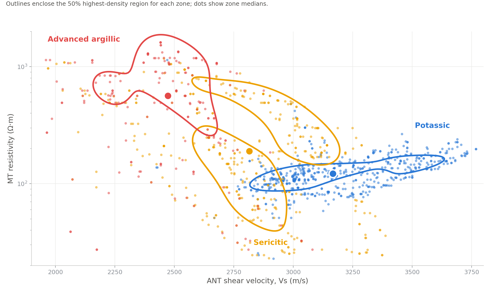
Alteration zones defined independently from downhole chemistry occupy distinct but overlapping regions of ANT velocity–MT resistivity space. Downhole measurements were composited into non-overlapping 30 m intervals before comparison with the geophysical models. Outlines enclose the 50% highest-density region for each zone; dots show zone medians.
When ANT velocity and MT resistivity are considered together, the alteration zones occupy distinct but overlapping regions of physical-property space. Potassic alteration is concentrated toward higher seismic velocity and lower resistivity. Advanced argillic alteration occupies the opposite part of the plot, with lower velocity and higher resistivity. Sericitic alteration spans the space between them.
The two geophysical properties do not contribute equally. At this site, ANT velocity provides the clearest separation between alteration zones. MT adds complementary information about electrical behaviour, which is influenced by conductive minerals, fluids and their connectivity.
■ The geophysical response changes systematically across the alteration zones
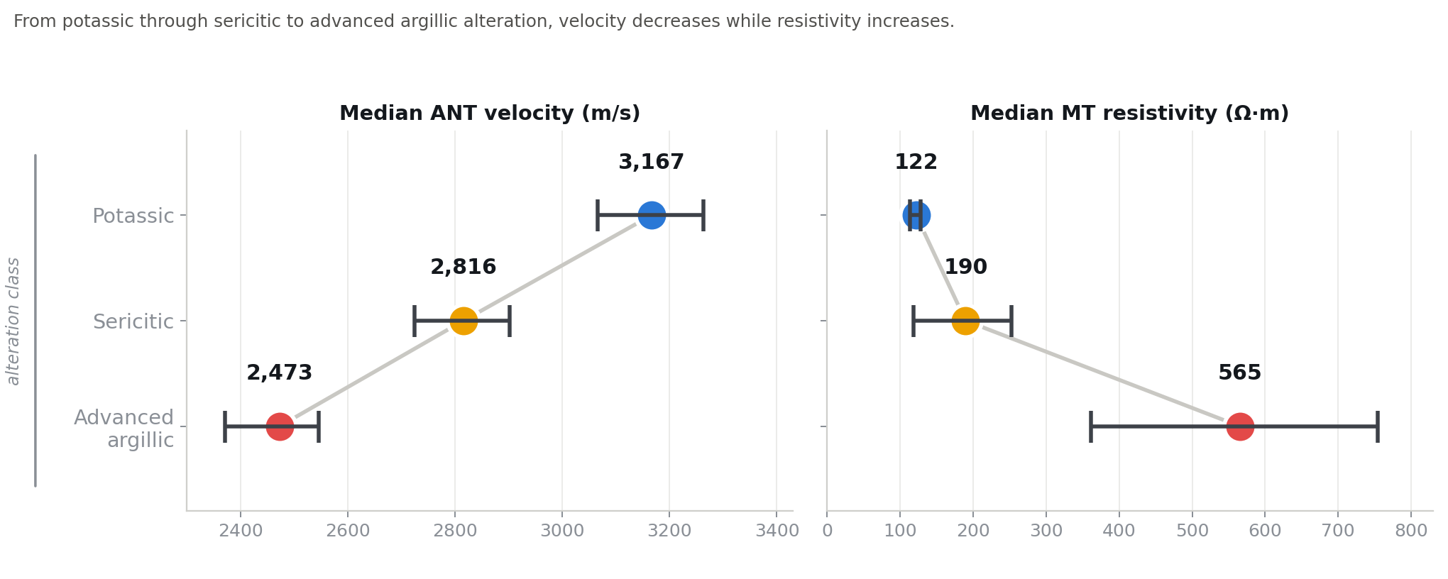
Median ANT velocity and MT resistivity across the three alteration classes. Error bars show 95% confidence intervals based on variation between drillholes. The same result becomes clearer when we compare the median response of each alteration class. ANT velocity decreases from potassic through sericitic to advanced argillic alteration. MT resistivity increases overall, with advanced argillic alteration clearly more resistive, while potassic and sericitic overlap. Together, the two properties show a systematic change across alteration classes defined independently from the geophysics.
■ The mineral assemblages behind the pattern
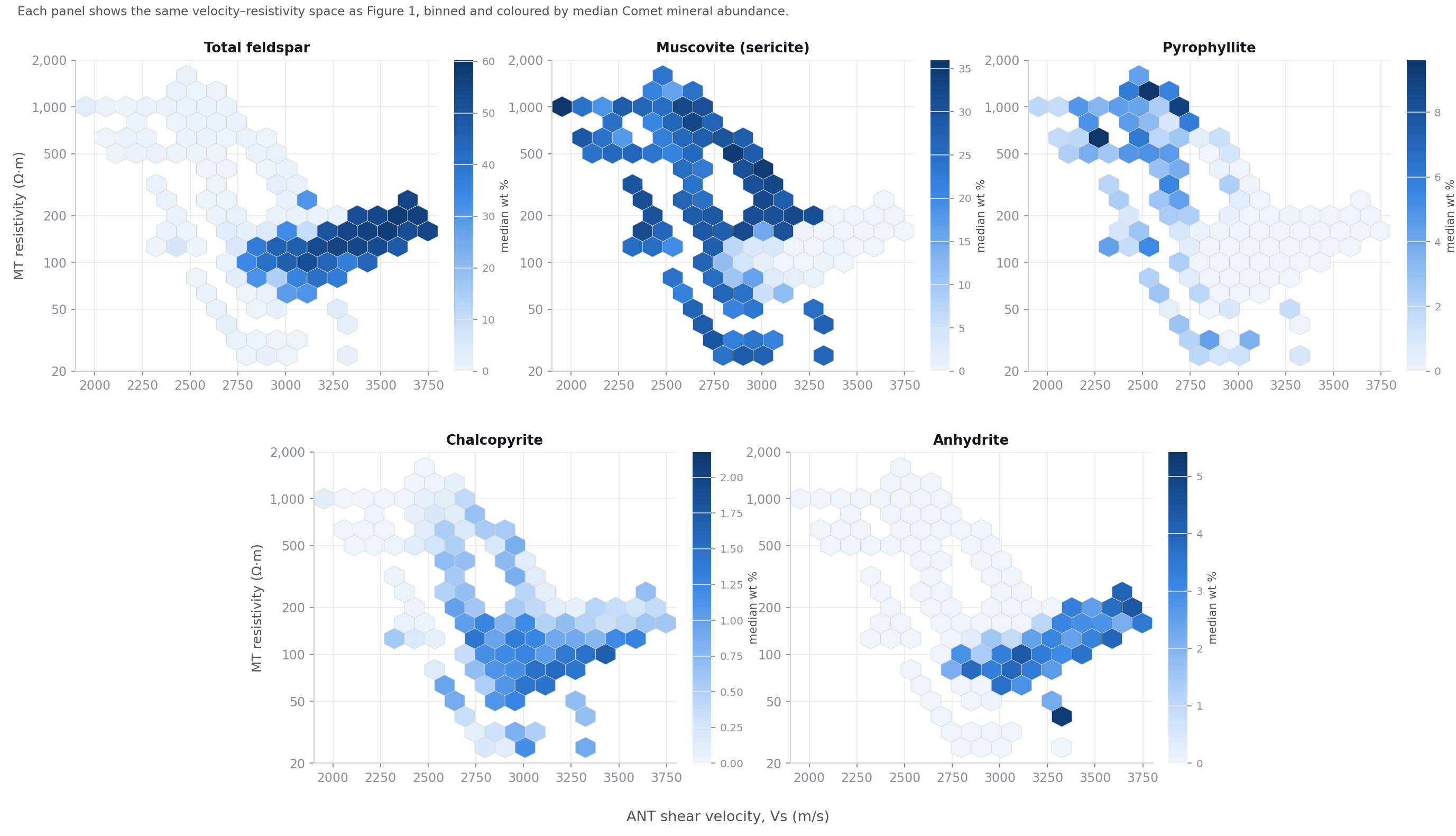
Median Comet mineral abundance across ANT velocity–MT resistivity space, based on 1,186 thirty-metre windows from 37 drillholes. Each panel uses its own colour scale; blank cells contain insufficient data. Comet allows us to examine this relationship at the level of individual minerals. Each panel in Figure 3 shows the same velocity–resistivity space, now coloured by the median abundance of one mineral measured in the drillholes.
How to read this figure: Total feldspar is concentrated toward higher velocity and lower resistivity, the part of the property space associated with potassic alteration. Muscovite and pyrophyllite become more abundant toward lower velocity and higher resistivity, consistent with the sericitic and advanced argillic parts of the system. Chalcopyrite and anhydrite show additional associations within the higher-velocity, lower-resistivity region.
No single mineral uniquely determines either velocity or resistivity. The geophysical response reflects the combined effects of the mineral assemblage, its texture and connectivity, and the wider physical state of the rock. What matters is that the mineral distributions reproduce the same broad organisation seen in the independently defined alteration zones.
■ Why this matters for exploration
Exploration teams rarely need another anomaly. They need to understand what an anomaly is likely to represent, how it relates to the mineral system and whether it should change what they do next.
This analysis shows that alteration domains defined from drillhole chemistry are systematically associated with ANT velocity and MT resistivity at the drilled locations. It gives us a practical way to bring mineralogical meaning to the 3D physical-property models.
The next step is to test whether those relationships can predict alteration in held-out drillholes. If they can, the geophysical volume could be used to infer how alteration domains may continue between the holes, identify untested volumes with similar physical signatures and guide drilling toward the parts of the system that matter most.
The goal is not to replace drilling or claim that geophysics measures mineralogy directly. It is to make each hole more informative by connecting what it reveals to the larger physical-property context around it.
■ Bringing geophysics back to the rock
In the field, geology works by moving between scales. A mineral helps explain the rock. The rock helps explain the outcrop. The outcrop helps us understand the mineral system.
Fleet is creating a similar connection between drillhole observations and geophysical models. Comet provides quantitative mineralogy along the holes, while ANT and MT provide 3D models of physical properties through the surrounding volume. At this deposit, alteration mineralogy observed in drilling is systematically expressed in the corresponding geophysical response.
Geophysics is normally interpreted through geological labels. Fleet now has a practical way to connect 3D geophysics to downhole mineralogy and interpret the physical-property models as part of the mineral system.
You might also like
.png)