Beyond prediction: Subsurface World Models
Dr Gerrit Olivier
Chief Scientific Officer

EXECUTIVE SUMMARY
As mineral exploration moves deeper beneath cover, the challenge is not to identify and target promising anomalies. It is to reconstruct a hidden three-dimensional geological system from sparse and indirect evidence, then decide which new observation would improve that understanding most. This is closely related to problems in physical AI, where a world model must infer an unseen or partially observed state, update that representation as evidence arrives, and choose what action to take next.
My research asks whether a subsurface world model trained on process-guided synthetic geological worlds can learn both to reconstruct hidden three-dimensional geology and to decide what should be measured next. Because the complete synthetic subsurface is known, the model can learn from counterfactual measurements, including the outcomes of drillholes that were never made in the real world. As new evidence arrives, it updates its representation of the subsurface and uses that evolving state to guide the next observation.
The goal is a new kind of exploration system: one that does not simply generate predictions, but helps geoscience teams reduce uncertainty, test competing interpretations and make better-informed decisions about where to explore, what to measure and how to allocate costly drilling.
Over the last few years, large language models have changed how many of us think about and engage with information, software and work. The harder question now is how far that capability carries into the real physical world, and whether a 'convincing answer' can survive contact with reality.
LLMs, reasoning models and AI agents are powerful tools. They can synthesise vast amounts of information, reason through complex questions and carry out multi-step tasks. What started as “vibe coding” has rapidly become something closer to agentic science and engineering.
But their ability to work with language and information does not necessarily translate into an understanding of the physical world. There is still a fundamental limitation. These systems are strongest when the world can be represented as text, code, documents, tables or tool calls. They are much weaker when success depends on a grounded understanding of physical structure, geometry and causality.
Said bluntly: putting a wrapper, or agent harness, around an LLM does not yet create a world-class geologist. Connecting an LLM to geological data, software and tools can extend its capabilities, but does not automatically give it the spatial and quantitative understanding needed to reconstruct the subsurface. Producing a convincing geological explanation is different from understanding how rock formations, structures and mineralisation fit together in three dimensions.
A language model can produce a fluent geological explanation, summarize an exploration report, describe a mineral system, suggest plausible interpretations and digest enormous volumes of heterogeneous data. But linguistic fluency and broad reasoning are not the same as maintaining a quantitative, spatially grounded representation of a hidden three-dimensional physical system.
That being said, the latest frontier models are already surprisingly capable. In our held-out drilling tests, Claude Opus 5.5 and Claude Fable 5.1 both outperformed conventional geostatistical baselines when constructing resource estimates and predicting drill outcomes, with performance broadly comparable to that of mid-career geologists. Their written analyses often identify components of the mineral system, weigh competing geological interpretations and compare the evidence with known deposit analogues (much as a geologist might). But the emerging lesson from physical AI is that general-purpose reasoning is not always enough. For tasks that depend on a quantitative understanding of three-dimensional structure and spatial relationships, specialized models trained directly on the physical world they are trying to understand can substantially outperform even the strongest general-purpose models.
Our tests explore that possibility for the subsurface. This is where the concept of a world model becomes interesting.
Fei-Fei Li has described a world model as an AI model that understands the three-dimensional structure, shape and compositionality of the world. Most current discussions around world models focus on robotics, autonomous driving and embodied AI. A robot must infer the world around it, predict what might happen next and choose useful actions. But one of the most important opportunities for world models lies somewhere else: beneath our feet.
Discovering deposits, extending known mineralisation and growing resources all depend on reasoning about a hidden world. We observe the fingerprints at the surface. After that we collect gravity, magnetic, electromagnetic, seismic, geochemical and remote-sensing data. We drill a tiny number of holes into an enormous volume. From these sparse observations, we try to infer the geological system that produced them and decide where to observe next.
The subsurface as a hidden world
Whether we are searching for a new deposit or assessing extensions to a known resource, we face the same challenge: understanding a deep, hidden three-dimensional world from sparse and indirect evidence. The easier deposits have largely been found and the remaining opportunities are increasingly difficult to observe directly. Even in well-drilled systems, important questions remain about what lies between drillholes, beyond existing boundaries or at depth. Answering those questions requires us to reconstruct uncertain geological systems from incomplete measurements.
I should point out that the underlying problem is extremely difficult. Mineral systems are the result of long histories of tectonic, magmatic, metamorphic, hydrothermal and geochemical processes. These processes interact across enormous ranges of spatial and temporal scales. We do not observe the vast majority of that history directly. Instead, we see only indirect and incomplete traces of the processes that produced the geology we observe today.
A surprising (although obvious in hindsight) realisation I have made is that geoscientists already train internal world models, which we call experience and intuition. When an experienced geologist looks at a map, a gravity anomaly, a magnetic trend, a few drillholes and some geochemistry, they are not simply recalling patterns they have previously seen. They are constructing a three-dimensional mental model of what could be happening underground. They imagine stratigraphy, structure, alteration, intrusions, fluid pathways, traps and target zones. They ask whether the observations are consistent with a plausible mineral system.
However, a human geoscientist can only construct and test a small number of possible subsurface worlds. They can sketch a few hypotheses, run selected inversions and test selected scenarios, but the space of plausible geological models is enormous.
The deeper you go, the worse the problem becomes. Many different geological worlds can explain the same observations. This is why I have increasingly come to believe that the conventional workflow (invert geophysical data into a property model, then interpret that model geologically) may not be the most effective route to understanding the subsurface. Rather than treating the inversion as the answer, we can treat the original measurements as evidence and use them, together with drilling and geological knowledge, to infer a distribution of plausible hidden geological worlds.
Figure: A subsurface world model combines heterogeneous surface observations and sparse drillholes to infer a hidden 3D state.

From inversion to learned world models
Geophysical inversion was a powerful response to the computational and data constraints of its time. Most geophysical inverse problems contain far more unknowns than observations, so the data alone cannot determine a unique subsurface model. To make the problem tractable, we impose regularization: smoothness, sparsity, damping, reference models, bounds and other prior assumptions. These choices were necessary, but they also bias and shape the answer. The resulting model is therefore not simply what the data says, it is instead one stable solution selected from a much larger family of geological worlds that could explain the same observations. In recent years, many geophysicists have started thinking about geological hypothesis testing as the Future of Earth Imaging, but this process typically still relies on manually designed and hand-crafted implicit geological models that could impose the same biases.
I find Jef Caers’ critique of this workflow particularly compelling. Geological assumptions first shape the regularisation used to stabilise the inversion, then enter again when the resulting property model is interpreted. In effect, the same prior can be imposed twice, narrowing the solution towards a preferred interpretation rather than exposing the full range of geological worlds consistent with the observations.
That does not make inversion wrong per se, but it makes it an artefact of an era in which geological knowledge had to be encoded manually and the objective was usually to recover a single preferred model. Deep neural networks offer a different computational regime. Instead of specifying every prior through a regularization term, we can learn geological priors from large populations of examples. Instead of reducing the observations to one smooth property volume, we can infer which three-dimensional geological worlds are plausible given the geophysics, drilling, surface geology and other available evidence.
Chess and Go underwent a comparable transition. Earlier systems relied heavily on human-designed evaluation functions and search heuristics. AlphaGo replaced much of the handcrafted evaluation with policy and value networks learned from expert games and self-play. The system became powerful because it had learned which states and actions were meaningful.
Geophysics is approaching a similar transition. The future is unlikely to abandon physics, forward modelling or inversion altogether, rather, these tools may become just another component of a broader learned system.
Physics constrains the synthetic worlds and generates their observable responses. Geophysical measurements can provide evidence about the real subsurface, but the neural network can learn the prior: the recurring structures, geometries and relationships that make some geological explanations more plausible than others.
The question then changes from “What is the subsurface model that explains these observations?” to “Given these observations, what subsurface worlds are plausible?”
This is a subtle but important shift. The goal is not simply to invert data into one answer, but to learn a conditional distribution over possible three-dimensional geological worlds.
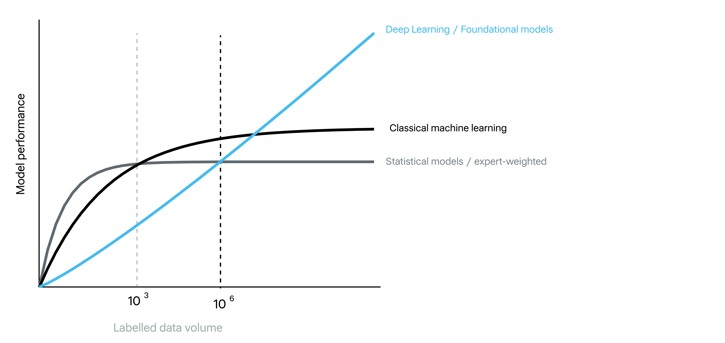
Figure: A conceptual view of the data-scaling problem. The crossover points are illustrative based on my personal experience, not measured thresholds. These lines can shift dramatically based on labelled data diversity and quality.
The data bottleneck
A major constraint on an AI breakthrough for subsurface understanding is that we do not have enough labelled geological data.
The figure above (modified from Andrew Ng’s course) captures the central pattern. With small labelled datasets, simple statistical models and traditional machine-learning methods can perform surprisingly well. They often reach useful performance quickly, but then begin to saturate. In this sparse-data regime, domain expertise can be especially powerful: expert-weighted models may outperform generic statistical approaches because they embed prior knowledge, accumulated experience and first-principles constraints that the data alone cannot reveal.
Deep neural networks behave differently. They may offer little advantage, and can perform worse, when training data is scarce. But their performance can continue improving as model capacity, compute and the amount of training signal increase by orders of magnitude. The 2012 AlexNet result was a decisive demonstration of this effect. AlexNet did not appear spontaneously: it combined a deep convolutional architecture with GPU acceleration and ImageNet, a dataset containing more than a million human-labelled images. The architecture did contain some novel aspects, but it only amounted to a breakthrough when applied to enough data and compute to exploit its capacity. In many modern AI breakthroughs, the critical moment was not the invention of a better algorithm in isolation, but the point at which data, compute and model scale crossed a threshold together.
Later breakthroughs widened the definition of useful training data. The original AlphaGo used millions of positions from expert human games to bootstrap its policy, then moved beyond imitation through reinforcement learning and self-play. AlphaGo Zero removed human games entirely, but only because the rules of Go provide a perfect simulator and an objective win-or-loss signal from which unlimited labelled experience can be generated.
AlphaFold used a different recipe. It anchored learning in a comparatively small but exceptionally detailed set of experimentally determined 3D protein structures, then amplified those labels with enormous protein-sequence databases, evolutionary constraints and self-distillation. GPT-3 transformed internet-scale text into hundreds of billions of automatic next-token targets, extracting implicit supervision from the accumulated output of human knowledge and communication.
Modern AI advances when a scalable model is supplied with a sufficiently large and informative training signal, together with enough compute to absorb it. That signal may come from human labels, experimental measurements, self-supervision, simulation, search, self-play or synthetic data. What these breakthroughs share is the ability to convert growing quantities of data and computation into continued improvement rather than reaching an early performance ceiling.
DeepMind’s decision to join Google reflected the same realization at an institutional level. Demis Hassabis has described access to compute and engineering infrastructure as a major reason for the deal. Once the algorithms were capable of benefiting from scale, experimental throughput (the ability to run vastly more training runs and tests) became a decisive competitive advantage.
Subsurface modelling faces the opposite problem. For any specific deposit class, the number of well-drilled, well-characterized deposits is very small. For the type of deposits I am interested in, the number of sufficiently drilled-out systems is probably less than 100, several orders of magnitude below the scale at which deep neural networks typically show their greatest advantage.
I think this helps explain why scaling AI for subsurface understanding has been difficult. We are trying to apply high-capacity learning systems to a domain where the real labelled dataset is tiny compared with the complexity of the task. We do not have an ImageNet-scale dataset of fully characterized 3D mineral systems. We have sparse drillholes, uneven sampling, inconsistent logging practices, biased discovery histories and commercially restricted data.
For the subsurface, the equivalent of ImageNet is unlikely to be a database of real deposits. There simply are not enough of them, and even for deposits we have found, the measurements are rarely complete, detailed and standardized. The scalable source of supervision has to be synthetic geological worlds: large, diverse, geologically and physically plausible environments in which the hidden 3D state is known and exploration observations can be simulated.
There is an analogy to early autonomous driving here worth making. Simulation and game-engine-style environments expose models to far more situations than can be safely or practically collected on roads (at least initially). The simulations are imperfect, but they allow useful structure and policies to be learned before adaptation and validation on real data.
Before mineral exploration can have an AlexNet, AlphaFold or AlphaGo-scale breakthrough, we need to generate large populations of plausible subsurface worlds, simulate their geophysical responses, sample counterfactual drillholes and train models both to reconstruct the hidden geology and to plan what to measure next. Our accepted paper is an early demonstration of that loop at scale.
Synthetic worlds instead of geological models
If synthetic data is the solution to the data bottleneck, the next question is obvious: how do we generate geological worlds at sufficient scale without reducing geology to geometric shapes?
Generating synthetic geology is not a new idea. Tools such as Noddy built three-dimensional models by applying sequences of geological events, including folding, faulting, intrusion and erosion. The later Noddyverse extended this idea to machine-learning scale, while frameworks such as GemPy and LoopStructural enabled increasingly sophisticated structural modelling.
These efforts were important foundations, but they were generally too simple for the problem we wanted to solve. Plausible layers, folds, faults and intrusions are not enough to represent an entire mineral system. We also need magmatic-hydrothermal processes, quantitative mineralogy, copper distribution, porosity, petrophysical properties, topography and the corresponding observations made by different sensors and techniques. Most importantly, we need to be able to drill anywhere in a model and know exactly what that hole would intersect.
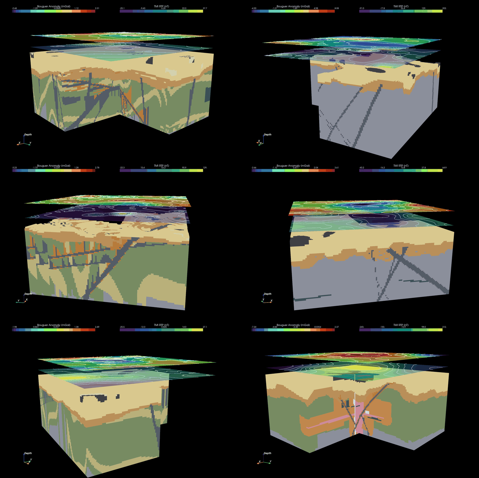
To address these limitations, we developed a process-guided approach focused initially on porphyry copper-molybdenum systems. Each world is built from a synthetic geological history. It begins with stratigraphic packages containing different combinations of sedimentary, volcanic and intrusive rocks. These packages can be folded, faulted, uplifted and eroded, then cut by multiple generations of intrusions and dykes. Younger faults offset older units, intrusions cross-cut their host rocks, and earlier structures influence the pathways available to later fluids.
The generator also represents the magmatic-hydrothermal processes responsible for alteration and mineralization. Intrusions release fluids whose temperature, pH and composition evolve as they move through the surrounding rocks, cool, mix and react with their host lithologies. Faults, fractures and intrusive contacts influence where those fluids travel, while distance from the heat source affects the temperatures at which minerals can form. Fluid pH, temperature and host-rock chemistry then determine which mineral assemblages are stable in each part of the system.
This means that mineralogy is not simply painted onto an arbitrary orebody. Higher-temperature fluids close to an intrusion produce a different assemblage from cooler fluids farther away. More acidic fluids favour different alteration reactions from neutral or alkaline fluids, while the same fluid can produce different minerals when it encounters a carbonate, volcanic or siliciclastic host rock. As conditions evolve, earlier minerals may also be replaced or overprinted by later alteration events. The resulting copper distribution emerges from the spatial overlap between intrusions, fluid pathways, reactive host rocks, alteration conditions and copper-bearing mineral phases.
We cannot solve the full physics and chemistry of reactive fluid flow from first principles. That would be too computationally expensive to repeat across millions of worlds, and our understanding of many ore-forming processes remains incomplete. Instead, the generator uses simplified process relationships to reproduce the geological logic of a porphyry system: geological history determines structure, structure and intrusions control fluid flow and temperature, fluid conditions control mineral stability, and mineralogy determines the resulting copper grade and physical properties.
Each completed world is then observed in the same way an exploration team might observe a real mineral system. We generate topography, mapped surface geology, geophysical and hyperspectral responses, and synthetic drillholes through the volume. The result is a hidden geological state with an internally consistent history, mineral composition and set of observable expressions.
A geological model describes a possible subsurface and typically focuses on lithologies. A synthetic geological world is a complete hidden state that can be observed, drilled, surveyed and used to evaluate decisions. This provides the supervision needed not only to reconstruct hidden geology, but also to learn which measurement should be made next.
Updating belief instead of predicting geology
Across discovery, expansion and resource growth, we do not actually need a static prediction of the subsurface, we want to know what to do next to move closer towards our goal.
Therefore a drillhole should not be viewed only as a test of a target. It is instead an expensive observation that changes our understanding of the wider system.
A useful hole may intersect mineralization, but it may also resolve ambiguity, constrain a contact, test the depth extent of a body, separate competing geological hypotheses or improve confidence in a target class.
The model should therefore answer two linked questions:
1) What does the hidden geology look like now?
2) Which new observation would most improve that estimate?
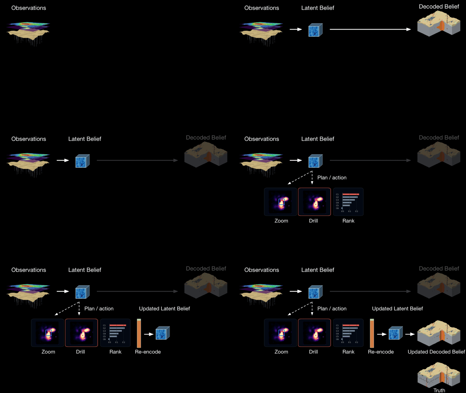
In our paper, this loop has two components. The reader combines observations (topography, surface lithology, gravity, magnetics, satellite data, seismic tomography and drill measurements) into a learned 3D state. A separate ranker then selects the candidate drillhole expected to produce the greatest improvement in the copper reconstruction.
In simple terms, the model asks: if I drilled here, what would I probably learn, and would that information improve my geological model? This is different from simply ranking the highest predicted target probability. The best hole may not be the one most likely to hit the current predicted target, instead it may be the one that most improves the model’s understanding of the wider system.
A high-grade confirmation hole may add little new information, while a lower-grade or even barren hole may be valuable if it eliminates a plausible interpretation or constrains the geometry between existing holes.
Jef Caers has argued for a similar shift: exploration should be organised around competing geological hypotheses, with new data acquired to eliminate incorrect interpretations and reduce uncertainty before focusing on grade and tonnage. This aligns closely with the active-measurement framing, in which the best drillhole is not always the one most likely to intersect mineralisation, but the one that best distinguishes between plausible geological worlds.
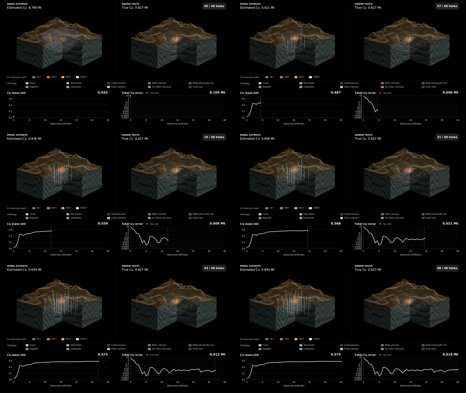
Figure: How our understanding of a synthetic deposit evolves as drilling accumulates (left) compared to the hidden truth (right). The Cu mass intersection over union (IoU) indicates how the model is able to spatially locate the Cu deposit, while the total error in resource estimate plateaus as drilling evolves. The example illustrates evidence assimilation and drill planning to determine the size and spatial extent of a deposit as efficiently as possible.
Closing the sim-to-real gap
Synthetic data is powerful because it provides a level of supervision that would be prohibitively expensive (and probably impossible) to obtain at scale in the real world. In each synthetic geological world, we know the complete hidden three-dimensional state. My rough back-of-the-envelope estimate is that acquiring an equivalent level of knowledge for a single real deposit could cost on the order of US$20 billion. Because the ground truth is fully known, we can determine what every candidate drillhole would have intersected, train the model to update its understanding as new evidence arrives, and run sequential exploration benchmarks in which both the hidden geology and the consequences of each possible measurement are known.
The central challenge is that synthetic geology is an approximation of real geology. A model may learn useful geological priors, but it can also learn the biases, omissions and shortcuts of the geological model generator. A convincing transfer test therefore needs to hide information the model has not seen and score a quantitative prediction against real measurements. In AI this is called the sim-2-real gap, and is a major subject in world modelling research for robotics and autonomous systems.
To test this we used a deliberately falsifiable setup: start from early, widely spaced drilling and ask our trained model (codename Tau) to estimate contained copper above a cut-off, then evaluate the estimate against drillholes that were held out from the model. We gave the same questions with the same context and data to Claude Opus 5.5, Claude Fable 5.1. and a conventional geostatistical approach.
In these tests, Tau outperformed both the conventional geostatistical baseline and the general-purpose language models on a quantitative subsurface task for both synthetic worlds and real deposits. This is encouraging evidence that the learned geological relationships can transfer beyond simulation.
On synthetic deposits held back from training, with early drilling spaced approximately 200–400 m apart, Tau’s error in total contained copper above a 0.2 % Cu cut-off was about 47 % lower than conventional geostatistics and 25–47 % lower than Anthropic’s Claude models (25 % lower than Fable 5.2, 33 % lower than Opus 5.5 and 47 % lower than Fable 5.1).
On two large real porphyry copper deposits, Tau predicted the copper metal above 0.2 % Cu along held-out drill holes with about 89 % less error than conventional geostatistics and about 40 % less error than Opus 5.5 and Fable 5.1, and matched Fable 5.2, Anthropic’s newest model. At a higher cut-off of 0.35 % Cu, Tau’s advantage widened: about 55 % less error than Fable 5.1 and Fable 5.2, and 64 % less than Opus 5.5.
It is evidence of the specific threshold we needed to cross: a model trained on imperfect synthetic geological worlds has learned priors that survive contact with real geology and can outperform both a conventional geostatistical approach and strong general-purpose language models on a quantitative subsurface task.
We now appear to have crossed a critical threshold: a model trained on imperfect synthetic geological worlds can make predictions and guide exploration decisions for real deposits better than current methods. I believe this marks an AlphaGo moment for geology.
The conclusion is not that synthetic data replaces real data. The two sources of supervision play different roles. Synthetic worlds provide scale, complete hidden states and counterfactual outcomes needed to train AI models with the capacity needed to make decisions in the real world. Real deposits reveal where the generator is wrong, calibrate the model and determine whether the learned representation is useful outside simulation.
The long-term training loop is therefore hybrid: broad synthetic pretraining, followed by calibration and validation on carefully curated real systems. The next decisive step that we are running with our clients currently is prospective evaluation - ranking candidate measurements before their outcomes are known, assimilating each new result and measuring whether the sequential policy improves decisions over an entire exploration or drilling campaign.
Figure: Instead of using observations to come up with a “best” model, the network described in our paper is trained end-to-end to simultaneously reconstruct 3D geology and optimally plan drilling to improve that reconstruction. Planning happens in compressed latent space, resembling what an experienced geologist would do.
A different way to think about subsurface AI
Much of the current AI discussion across discovery, expansion and resource development is still framed around prediction. Can we predict mineralization? Can we predict lithology? Can we predict drill success?
These are logical and important questions, but they are incomplete given the uncertainties we face. Finding and growing resources involves a sequence of decisions under uncertainty, with each new observation informing what we do next.
A useful subsurface AI system should therefore help answer:
- What geological worlds are consistent with the current evidence?
- Where is the model uncertain in a way that matters to the decision?
- Which observation would most improve the reconstruction or distinguish competing hypotheses?
- Which drillholes are likely to change the interpretation rather than merely confirm it?
- When is the evidence strong enough to drill, gather another type of data, or relinquish the target?
This is why I find the world-model framing so compelling. It connects geological reconstruction, uncertainty and action. The model is not a model generator, it is an evidence-updating system whose internal state is useful for deciding what to measure next.
For decades, decisions about mineral discovery, resource expansion and development have relied on interpretations of incomplete and non-unique subsurface data. We have become very good at building individual models, running inversions and testing selected hypotheses. But the subsurface does not present us with a single answer, it presents us with a set of plausible worlds constrained by imperfect evidence.
Subsurface world models offer a different paradigm.
Rather than asking only “What is the subsurface?”, we can ask, “Given the evidence we have, what hidden structure is supported, and what observation should we make next?”
The next generation of subsurface AI should be built to reason about the subsurface itself, not simply to add a language layer to existing workflows. It should learn the hidden structure of the Earth, represent uncertainty explicitly, update its state as evidence arrives and help us decide how to reduce that uncertainty through better observations.
In other words, it should help us understand what lies beneath our feet and make better decisions about how to discover, extend and grow mineral resources.
Conclusion
A geological model can look convincing and still be wrong. Every geologist knows the experience: an elegant interpretation and a beautiful model that fails when the next drillhole arrives. The real test is not whether a model is plausible, but whether it improves when confronted with new evidence.
Synthetic worlds let us expose errors and test decisions at a scale that is impossible in the field. Real drilling remains the final judge and each new observation should challenge the current interpretation, update the model and improve the next decision. The goal is to teach an AI model to perform a continuous cycle of prediction, measurement and learning, so the system learns not only to predict the subsurface, but to explore it.
Paper: World Models for Active Measurement: Revealing Static Hidden Worlds and Planning What to Measure Next - Gerrit Olivier and Jack B. Muir. Accepted to the NeurIPS 2026 Workshop on World Models in Physical AI. OpenReview
You might also like